React Map GL Draw
react-map-gl-draw is a react based drawing library tailored for react-map-gl.
Options
mode(Object, Optional) - A mode instance. default to null.
Support the following modes from @nebula.gl/edit-modes. Note: Currently react-map-gl-draw does not support modeConfig in @nebula.gl/edit-modes.
DrawCircleByDiameterMode: Lets you draw a GeoJsonCirclefeature.DrawCircleFromCenterMode: Lets you draw a GeoJsonCirclefeature.DrawPointMode: Lets you draw a GeoJsonPointfeature.DrawLineStringMode: Lets you draw a GeoJsonLineStringfeature.DrawPolygonMode: Lets you draw a GeoJsonPolygonfeature.-
DrawRectangleMode: Lets you draw aRectangle(represented as GeoJsonPolygonfeature) with two clicks - start drawing on first click, and finish drawing on second click.- If you'd like to starting drawing by mouse down and end drawing by mouse up, you can use
modeConfig: {dragToDraw: true}. SeemodeConfigfor more details.
- If you'd like to starting drawing by mouse down and end drawing by mouse up, you can use
And an advanced
EditingMode: Lets you select and drag vertices; and drag features.modeConfig(Object, Optional) - Additional configuration for the provided mode. Checknebula.gldoc to see mode details.features(Feature[], Optional) - List of features in GeoJson format. Iffeaturesare provided from users, thenreact-map-gl-drawrespect the users' input, and therefore ignore any internalfeatures. But iffeaturesare not provided, thenreact-map-gl-drawmanagesfeaturesinternally, and users can access and manipulate the features by callinggetFeatures,addFeatures, anddeleteFeatures.selectedFeatureIndex(String, Optional) - Index of the selected feature.clickRadius(Number, Optional) - Radius to detect features around a hovered or clicked point. Default value is0-
onSelect(Function, Optional) - callback when clicking a position whenselectableset to true. Receives an object containing the following parametersselectedFeature: selected feature.nullif clicked an empty space.selectedFeatureIndex: selected feature index.nullif clicked an empty space.editHandleIndex: selected editHandle index.nullif clicked an empty space.screenCoords: screen coordinates of the clicked position.mapCoords: map coordinates of the clicked position.
-
onUpdate(Function, Optional) - callback when any feature is updated. Receives an object containing the following parametersdata(Feature[]) - the updated list of GeoJSON features.editType(String) -addFeature,addPosition,finishMovePositioneditContext(Array) - list of edit objects, depend oneditType, each object may containfeatureIndexes,editHandleIndexes,screenCoords,mapCoords.
Feature object structure:
{
  id, // an unique identified generated inside react-map-gl-draw library
  geometry: {
    coordinates, // latitude longitude pairs of the geometry points
    type // geojson type, one of `Point`, `LineString`, or `Polygon`
  },
  properties: {
    renderType, // Mainly used for styling, one of `Point`, `LineString`, `Polygon`, or `Rectangle`. Different from `geometry.type`. i.e. a rectangle's renderType is `Rectangle`, and `geometry.type` is `Polygon`. An incomplete (not closed) Polygon's renderType is `Polygon`, `geometry.type` is `LineString`
    ...otherProps // other properties user passed in
  }
}
Styling related options
-
featureStyle(Object|Function, Optional) : Object - Either a style objects or a function to style a feature, function parameters arefeature: feature to style.index: index of the feature.state: one ofSELECTED,HOVERED,INACTIVE,UNCOMMITTED,CLOSING.
Returns is a map of style objects passed to SVG path elements.
-
featureShape(String|Function, Optional): if is a string, should be one ofrectorcircle. If is a function, will receive the following parametersfeature: feature to style.index: index of the feature.state: one ofSELECTED,HOVERED,INACTIVE,UNCOMMITTED,CLOSING.
-
editHandleStyle(Object|Function, Optional) : Object - Either a style objects or a function to style aneditHandle, function parameters arefeature: feature to style.index: index of the editHandle vertex in the feature.state: one ofSELECTED,HOVERED,INACTIVE,UNCOMMITTED,CLOSING.shape: shape resolved fromeditHandleShape.
Returns is a map of style objects passed to SVG circle or rect elements.
-
editHandleShape(String|Function, Optional): if is a string, should be one ofrectorcircle. If is a function, will receive the following parametersfeature: feature to style.index: index of the editHandle vertex in the feature.state: one ofSELECTED,HOVERED,INACTIVE,UNCOMMITTED,CLOSING.
Explanations
Feature: any drawn shape, one of point, line, polygon or rectangle.EditHandle: vertex of the feature being edited.
State related concepts:
INACTIVE: neither selected nor hovered, default state of a completefeatureoreditHandle.SELECTED: being clicked or dragged.HOVERED: hovered over by the mouse pointer.UNCOMMITTED: in the middle of drawing, not yet added to the feature being edited.CLOSING: closing a polygon.
Styling based on state:
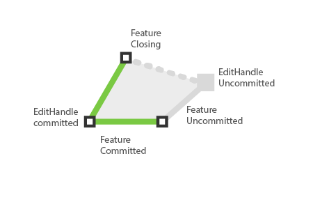
As shown in the above image, for the feature currently being edited,
featureStyle({feature, state: SELECTED})will be applied to the committed parts of the feature. (Green strokes)editHandleStyle({state: SELECTED})will be applied to the committed editHandle vertices. (Vertices with black stroke)featureStyle({feature, state: UNCOMMITTED})will be applied to the uncommitted parts of the feature. (Gray stroke)editHandleStyle({state: UNCOMMITTED})will be applied to the uncommitted editHandle vertex. (Gray vertex)
Methods
getFeatures
- Return a list of finished GeoJson features.
addFeatures (Feature | Feature[])
- Add a single or multiple GeoJson features to editor.
deleteFeatures (Feature | Feature[])
- Delete a single or multiple GeoJson features to editor.
Know Issues
@turf/difference: If you are seeing the below error, you can force@turf/difference's version in your projectpackage.jsonfile and redoyarn install.
./node_modules/@turf/difference/index.mjs Can't import the named export 'diff' from non EcmaScript module (only default export is available)
{
  ...,
  "dependencies": {
    ...
  },
  "resolutions": {
    "@turf/difference": "6.0.1"
  }
}
references:
- yarn
@turf/differenceissue- related issues: issues/335 issues/333
Code Example
Basic example: Draw polygon
import * as React from 'react';
import MapGL from 'react-map-gl';
import {
  Editor,
  DrawPolygonMode,
} from 'react-map-gl-draw';

const DEFAULT_VIEWPORT = {
  width: 800,
  height: 600,
  longitude: -122.45,
  latitude: 37.78,
  zoom: 14,
};

class App extends Component {
  constructor(props) {
    super(props);
    this.state = {
      viewport: DEFAULT_VIEWPORT,
      modeHandler: null,
    };
  }

  _updateViewport = (viewport) => {
    this.setState({ viewport });
  };

  render() {
    const { viewport } = this.state;
    return (
      <MapGL
        {...viewport}
        width="100%"
        height="100%"
        mapStyle={'mapbox://styles/mapbox/light-v9'}
        onViewportChange={this._updateViewport}
      >
        <Editor
          // to make the lines/vertices easier to interact with
          clickRadius={12}
          mode={new DrawPolygonMode()}
        />
        {this._renderToolbar()}
      </MapGL>
    );
  }
}
Add customized styles
This is continuous example extends from the Basic Example. Check default style used in editor for more details.
<Editor
  // to make the lines/vertices easier to interact with
  clickRadius={12}
  mode={new DrawPolygonMode()}
  featureStyle={({feature, state}) => {
    if  (state === RENDER_STATE.SELECTED) {
      return {
        stroke: 'rgb(38, 181, 242)',
        fill: 'rgb(189,189,189)'
     }
    }
    return {
      stroke: 'rgb(189,189,189)',
      strokeDasharray: '4,2',
    };
  }}
  editHandleStyle={({feature, shape, state}) => {
    if (state === RENDER_STATE.SELECTED) {
      return {
        stroke: 'rgb(38, 181, 242)',
        fill: 'rgb(189,189,189)'
     }
    }
    return {
      stroke: 'rgb(189,189,189)',
      strokeDasharray: '4,2',
    };
  }}
  editHandleShape={'circle'}
/>
Advanced example: multiple draw modes and editing drawn features
import React, { Component } from 'react';
import MapGL from 'react-map-gl';
import {
  Editor,
  EditingMode,
  DrawLineStringMode,
  DrawPolygonMode,
} from 'react-map-gl-draw';

const MODES = [
  { id: 'drawPolyline', text: 'Draw Polyline', handler: DrawLineStringMode },
  { id: 'drawPolygon', text: 'Draw Polygon', handler: DrawPolygonMode },
  { id: 'editing', text: 'Edit Feature', handler: EditingMode },
];

const DEFAULT_VIEWPORT = {
  width: 800,
  height: 600,
  longitude: -122.45,
  latitude: 37.78,
  zoom: 14,
};

class App extends Component {
  constructor(props) {
    super(props);
    this.state = {
      viewport: DEFAULT_VIEWPORT,
      modeId: null,
      modeHandler: null,
    };
  }

  _switchMode = evt => {
    const modeId = evt.target.value === this.state.modeId ? null : evt.target.value;
    const mode = MODES.find(m => m.id === modeId);
    const modeHandler = mode ? new mode.handler() : null;
    this.setState({modeId, modeHandler});
  };

  _renderToolbar = () => {
    return (
      <div style={{position: 'absolute', top: 0, right: 0, maxWidth: '320px'}}>
        <select onChange={this._switchMode}>
          <option value="">--Please choose a draw mode--</option>
          {MODES.map(mode => <option key={mode.id} value={mode.id}>{mode.text}</option>)}
        </select>
      </div>
    );
  };

  _updateViewport = (viewport) => {
    this.setState({ viewport });
  };

  render() {
    const { viewport, modeHandler } = this.state;
    return (
      <MapGL
        {...viewport}
        width="100%"
        height="100%"
        mapStyle={'mapbox://styles/mapbox/light-v9'}
        onViewportChange={this._updateViewport}
      >
        <Editor
          // to make the lines/vertices easier to interact with
          clickRadius={12}
          mode={modeHandler}
        />
        {this._renderToolbar()}
      </MapGL>
    );
  }
}